Bike training route


- 0:30 h
- 3.09 km
- 68 m
- 68 m
- 1,245 m
- 1,310 m
- Difficulty: medium
- Start: Blitzingen, Bodme
- Destination: Blitzingen, Bodme
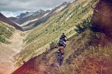
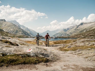
The bike training route is considered a technically demanding circuit. It originated thanks to the "Bike Race Goms", which is regarded among insiders of the cross-country scene as a special event. At a fast pace, the biker sweeps over lush mountain meadows and tricky single trails in the descending mountain forest. The perfect route to work on your own fitness.

Good to know
Pavements
Best to visit
Directions
Bodme - Zeit - Lärch - Bodme - Bifiga - Bodme
Tour information
Loop Road
Stop at an Inn
Equipment
We recommend:
- Technically perfect bike or bicycle with bell
- Bicycle helmet and gloves
- Sun and rain protection as well as warm clothing
- Detailed map or information material with good route preparation
- Provisions for your day in the open nature
- First-aid kit and mobile phone for emergencies
Directions & Parking facilities
From Brig, follow the cantonal road No. 19 (Furka road) for about 25 km to Blitzingen.
The Goms is also well connected from the Zurich / Lucerne region via Andermatt - Furka car shuttle train www.matterhorngotthardbahn.ch.
With the regional trains of the Matterhorn Gotthard Railway you can reach Blitzingen from Brig in 56 min. The Goms is also easily accessible from the Zurich / Lucerne region via Andermatt - Furka Base Tunnel.
The timetables of trains and buses can be found at www.sbb.ch.
Additional information
- Summer report at www.goms.ch/sommersportbericht
- Timetable www.sbb.ch
- Emergency phone number: 144
Literature
In the tourist information offices as well as in most hotels and restaurants in Obergoms you will find the following brochures:
- Obergoms summer map with hiking, biking and bike routes
- Holiday guide
Author´s Tip / Recommendation of the author
The bike race takes place in Blitzingen in July. You can find all the information you need at:
Safety guidelines
Use of bike and bicycle paths is at your own risk. The Obergoms Tourism AG rejects any liability and assumes no responsibility for the accuracy and completeness of the information on this website.
Carry a bike map with you or download the complete description of the bike path with a large scale map. During your route, it is advisable to use only marked paths and roads. Respect the rules of Swiss road traffic and observe all signposts and instructions – for your own safety, for the protection of the landscape and out of respect for wildlife. Behave considerately toward other path users. Take your waste and the waste of others with you.
Weather conditions can change very quickly and without warning in the mountains. Appropriate clothing and enough provisions (food and drink) are very important. In case of unstable weather, it's better to turn back early.
Carry additional sun protection. UV rays at high altitudes can be very strong, even when the sky is overcast.
Plan your route carefully and thoroughly. Inform yourself in advance about the current conditions and weather situation. The summer report www.goms.ch/sommersportbericht provides valuable information from the region.
Map
Hiking map Goms, Rotten Verlag, 1:25‚000
Topographic maps 1:25,000 Swisstopo: 1270 Binntal
Nearby


Download GPX file