Glacier Bike Tour 8. Andermatt - Ulrichen


- 2:30 h
- 42.80 km
- 1,030 m
- 1,120 m
- 1,344 m
- 2,429 m
- Difficulty: medium
- Start: Andermatt (1437 m)
- Destination: Ulrichen (1346 m)
For its eighth stage, the Glacier Bike Tour (GBT) starts from Andermatt before reaching the source of the Rhone in Valais, passing through the Furka Pass. On this section, you will have the chance to discover one of the most beautiful villages in Switzerland, as well as the smallest village, while the climb to the Furka Pass will make you ascend nearly 900 meters of elevation. At the top, cross the cantonal border to take your first steps in Valais and, after a few descending turns, discover the Rhone glacier, where the river takes its source, as well as the emblematic Belvédère hotel, which is currently no longer in operation. The descent offers a splendid view of the imposing 4000-meter peaks of the Valais and Bernese Alps. On the way to the Goms valley (Conches), the alpine landscape is replaced by forests and finally opens onto a vast picturesque expanse. Surrounded by the Furka, Grimsel and Nufenen passes, you reach Ulrichen, the destination of your stage.

Good to know
Best to visit
Directions
From Andermatt, follow the Reuss along the Andermatt golf course and make a first stop at Hospental, one of the most beautiful villages in Switzerland, then at Zumdorf, the smallest village in the country. Then continue your route towards Realp and the east ramp of the Furka Pass, passing through the Urseren plain. The ascent to the pass, steady and demanding, includes 900 meters of elevation gain over twelve kilometers. At the top, cross the cantonal border before tackling the first bends of the descent. At 2200 meters altitude, you arrive at the Rhone glacier, a river you will follow for many kilometers. Pass in front of the Belvédère hotel and continue your descent along the hairpin bends, before heading towards Gletsch and, further on, towards the Goms valley (Conches). In front of you, the alpine landscape is replaced by forests and eventually opens onto the picturesque expanse of the upper Goms valley and the Ulrichen plateau, the stage town of your route.
Tour information
Cultural Interesting
Stop at an Inn
Summit
Equipment
Which e-bike to take on the Glacier Bike Tour? Professional cyclist and two-time world E-MTB champion Nathalie Schneitter presents you in video the ideal two-wheeler. A robust and comfortable full-suspension e-bike, equipped with wide and grippy tires, powerful brakes and, if possible, a dropper post.
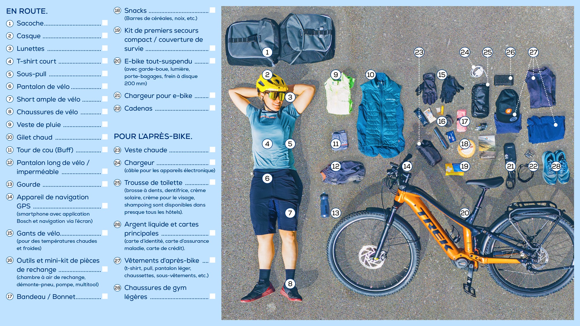
Even in the middle of summer, you have to be ready for anything in the mountains. So what should you pack in the bike bags for such a special adventure, which passes through three mountain passes and landscapes both alpine and Mediterranean? Professional cyclist Nathalie Schneitter has already ridden the Glacier Bike Tour and reveals here her packing list to take along.
Directions & Parking facilities
By car, take the motorway exit at Göschenen and continue 10 minutes towards Andermatt.
Follow parking signs in Andermatt.
Take the Gotthard Express train to Göschenen, then the Matterhorn Gothard Bahn to Andermatt.
Remember to reserve a place for your mountain bike via the SBB mobile app or on cff.ch.
Additional information
Book the Glacier Bike Tour stay offer! Choose the eleven, seven or three-night variant and enjoy wonderful days on an e-bike. You will stay in bike hotels and benefit from a daily luggage transport service, all you have to do is enjoy! To the offer.
See full itinerary:
Learn more about the destinations:
Literature
Consult the Valais/Wallis mountain bike map to discover the best routes in the region.
Tourist offices in Münster, Oberwald, Reckingen, Viège and Zermatt provide brochures for mountain biking in the region.
Author´s Tip / Recommendation of the author
If the sun is out, drop off your bags in Ulrichen, then go swimming, relax, or rent a stand-up paddle at Geschinersee.
Safety guidelines
Only follow marked trails and roads as well as appropriate signs. The Glacier Bike Tour route is under development and is not signposted. You can find your way on site using the Outdoor Active app.
Prepare your mountain bike outing
This route has not been approved under the leisure mobility routes law by the canton of Valais. People using this route based on the information on this website do so at their own risk. Local conditions may cause route modifications. We disclaim all liability for the accuracy and completeness of the website information. The mountain is a place of pleasure to share and respect. The mountain offers a space to meet and share unforgettable moments, on bike or on foot. For all outdoor enthusiasts to enjoy it, it is essential to share this space with respect for nature and agriculture. Respectful behavior allows everyone to practice their hobby in the best conditions. Inform yourself about the recommendations and rules in place.
Evaluate your physical condition and abilities well. Use of the different routes is always at your own risk.
Map
National maps SwissTopo 1:25,000:
1250 Ulrichen
Nearby


.jpeg")


