- Photos & Map
How would you like to arrive?
- Description
- Good to know
- Nearby
Download GPX file
- 1:30 h
- 2.85 km
- 180 m
- 175 m
- 1,288 m
- 1,470 m
- 182 m
- Start: Blitzingen, parking lot
- Destination: Blitzingen, village
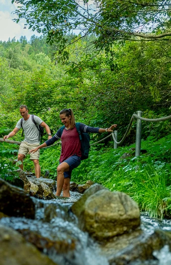
Kneipp yourself healthy. The longest natural Kneipp path in Switzerland brings body and soul into harmony. Health, performance, balance – we all wish for this. In Blitzingen, one of the longest natural Kneipp paths in Switzerland brings body and soul into harmony. Enjoy the soothing water in the great outdoors and kneipp yourself healthy! You walk through meadows, walk barefoot through cold mountain streams, practice sawing tree trunks, and learn about natural remedies. For the very brave, there is the icy cold shower under the waterfall or the refreshing bath in the mountain stream.
Points 5 and 6 are not accessible this year.
Good to know
Best to visit
Directions
The Kneipp path starts from the parking lot located at the junction of the Furka road towards Chaschtebiel. Then you follow the road and pass through the tunnel at the avalanche dam. From there, you follow the Kneipp path past the hamlets of Wilere and Ammern to the highest point of the route. From there, you follow the hiking trail back to the mountain village of Blitzingen.
Points 5 and 6 are not accessible this year.
Tour information
Loop Road
Equipment
Short pants or pants that can be rolled up are recommended.
Directions & Parking facilities
By car to Blitzingen.
There is a public parking lot at the junction in Blitzingen towards Chaschtebiel.
By train to Blitzingen station. Reachable from Brig by MGB in 56 minutes. Reachable from Göschenen by MGB in 1 hour and 26 minutes. The trains run hourly.
Additional information
Timetable www.sbb.ch
Emergency service phone number: 144
Literature
In the tourist information offices and in most hotels and restaurants in Obergoms, you will find the following brochures:
- Obergoms summer map with hiking trails, cycling and bike routes
- Vacation guide
Author´s Tip / Recommendation of the author
In good weather, Kneipping is definitely more fun.
Safety guidelines
Please observe the current conditions and recommendations at www.goms.ch/sommersportbericht
Map
Hiking map Goms, Rotten Verlag, 1:25,000
Topographic maps 1:25,000 Swisstopo: 1250 Ulrichen / 1270 Binntal
Nearby

