Mossmattentrail


- 3:30 h
- 20.25 km
- 855 m
- 855 m
- 1,327 m
- 2,126 m
- Difficulty: difficult
- Start: Ulrichen train station
- Destination: Ulrichen train station
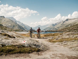
The Mossmattentrail is part of the Valais Panorama Bike route. This route starts at the Grimsel Pass and winds its way through the entire Valais region. The trail takes you from the Ulrichen train station along easily rideable forest roads to Chäller at 1,879 meters above sea level, where the path transitions into a newly built uphill singletrack. From there, you’ll need to push your bike part of the way to the highest point at 2,068 meters above sea level. The subsequent traverse against a breathtaking backdrop will make any biker’s heart race, leading you over flowing trails, hairpin turns, and occasionally soft forest ground all the way to the Geschinen train station. From Geschinen, you’ll take the official bike path back to the starting point in Ulrichen.
Translated with DeepL.com (free version)

Good to know
Pavements
Best to visit
Directions
The route starts at Ulrichen train station. First, follow the hiking trail towards Nufenen Pass. Just before the small bridge crossing the Aegina stream, leave the hiking trail and cross the Nufenen Pass road to reach the forest road (point 1583). From here, follow the forest road to the end at Chäller (point 1879). Here starts the uphill trail. You will have to push the bike at times. At a small alp at 2050 meters above sea level, the flowing and varied trail begins, first slightly rising, then gaining altitude. Follow the trail to a hiking trail intersection and turn northeast. Here starts a flowing downhill trail to Geschinen. In Geschinen, you either ride along the Rottenvelo path directly back to Ulrichen or first follow the bike path towards Brig to Münster, make a detour through the village, and return via Geschinen to Ulrichen, at the starting point of the route.
Tour information
Loop Road
Stop at an Inn
Equipment
We recommend:
- Technically flawless bike
- Bike helmet and gloves
- Sun and rain protection as well as warm clothing
- Detailed map or information material with good route preparation
- Provisions for your day in the open nature
- First aid kit and mobile phone for emergencies
Directions & Parking facilities
Accessible by train and bus.
Take the Matterhorn Gotthard Bahn to Ulrichen train station.
Remember to reserve a spot for your mountain bike via the SBB Mobile App or on sbb.ch.
Additional information
Literature
In tourist information offices as well as in most hotels and restaurants in Goms, you will find the following brochures:
- Summer map Goms with hiking, bike, and mountain bike routes
- Summer magazine
Author´s Tip / Recommendation of the author
A highlight in autumn when the larch trees glow golden.
Safety guidelines
Plan your route carefully and thoroughly. Inform yourself beforehand about the current conditions and weather. The summer report provides valuable information from the region.
As an alpine trail, the Moosmattentrail may be affected locally and temporarily by weather conditions, remaining snow, or natural events. Especially after winter or severe weather, there may be occasional sections where you need to push or carry your bike.
Map
- Goms hiking map, Rotten Verlag, 1:25,000
- Topographic maps 1:25,000 Swisstopo: 1250 Ulrichen
Nearby


Download GPX file