


- 2:10 h
- 3.64 km
- 90 m
- 330 m
- 2,235 m
- 2,476 m
- 241 m
- Start: Furkapass, Pass height
- Destination: Furkapass, Pass height
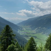
The trail takes us comfortably from the Furka Pass to a unique vantage point above the Rhone Glacier. This place is also attributed to the Rhone spring.
Good to know
Pavements
Best to visit
Directions
Tour information
Familiy-Friendly
Equipment
- Good footwear and walking sticks
- Sun and rain protection and warm clothing
- Detailed map or information material with good tour preparation
- Provisions for your day in the great outdoors
- Pocket pharmacy and mobile phone for emergencies
Directions & Parking facilities
The Goms valley is also easily accessible from direction Zurich / Lucerne via Andermatt – car transport Furka www.matterhorngotthardbahn.ch.
The timetables for all trains and busses can be found at www.sbb.ch.
Additional information
Time table www.sbb.ch
Telephone number of rescue service: 144
Literature
- Summer map of Obergoms with hiking paths and bike trails
- Holiday companion
Author´s Tip / Recommendation of the author
Safety guidelines
The great heat of the last few days has also left its mark on the Rhone Glacier. A strong melting can be observed on the glacier (partly with ice collapses). Due to this fact the already existing lake is getting bigger and bigger.
- Due to the retreat of the glacier, rockfalls can occur in the area of the "exposed slopes" at the accesses to the glacier, the grotto or the surrounding area.
- Also the stay on the glacier tongue as well as in the area of the lake is risky.
- The municipality of Obergoms therefore asks all persons staying in the area of the Rhone glacier to be aware of this danger and to behave accordingly (self-responsibility). (July 2022 / Municipality of Obergoms)
The use of the hiking trails is at your own risk. Obergoms Tourismus AG disclaims all liability and assumes no responsibility for the accuracy and completeness of the information on this website.
Take a map with you or download the complete description of the route with a large-scale map. Use only signposted paths and observe all markings and signs - for your own safety, for the protection of the landscape and in respect for wildlife. Be considerate of other users. Take your rubbish and that of others with you.
Weather conditions in the mountains can change very quickly and without warning. Adequate clothing and provisions (food and drink) are very important. If the weather is unstable, it is better to turn around early.
Carry additional sun protection with you. UV rays at high altitudes can be very strong, even when the sky is overcast.
Plan your tour carefully and in detail. Inform yourself in advance about the current conditions and weather conditions. The summer report provides you with valuable information from the region.
Map
National maps 1:25'000 Swisstopo: 133 Urseren
Nearby


