Circular route Grathorn


- 5:53 h
- 14.23 km
- 1,305 m
- 1,305 m
- 1,312 m
- 2,672 m
- Difficulty: difficult
- Start: Reckingen, station
- Destination: Reckingen, station
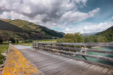
Our hike starts at Reckingen station and goes to the picturesque wooden bridge over the Rotten. Here we follow the hiking trail signpost towards Mannlibode. On a little road, we reach Blinne, which we cross and follow for a few hundred meters. In a clearing, the path branches off to the right and gently ascends into a magnificent pine forest.

Good to know
Pavements
Best to visit
Directions
Tour information
Loop Road
Summit
Equipment
We recommend:
- Good footwear and hiking poles
- Sun and rain protection as well as warm clothing
- Detailed map or information material with good route preparation
- Provisions for your day in the open nature
- First aid kit and mobile phone for emergencies
Directions & Parking facilities
From Brig, follow the cantonal road No. 19 (Furkastrasse) for about 30 km to Reckingen.
Goms is also well connected from the Zurich / Lucerne region via Andermatt - Furka car shuttle www.matterhorngotthardbahn.ch.
With the regional trains of the Matterhorn Gotthard Bahn, you can reach Reckingen from Brig in 1 hour 3 minutes. Goms is also easily accessible from the Zurich / Lucerne region via Andermatt - Furka base tunnel.
Timetables for trains and buses can be found at www.sbb.ch.
Additional information
Literature
At the tourist information points as well as in most hotels and restaurants in Obergoms you will find the following brochures:
- Obergoms summer map with hiking, cycling, and mountain biking trails
- Holiday guide
Author´s Tip / Recommendation of the author
The Gommer Pass of the Matterhorn Gotthard Bahn entitles the holder to free travel on the Oberwald - Fiesch Feriendorf route in 2nd class
Safety guidelines
The use of hiking trails is at your own risk. Obergoms Tourismus AG denies all liability and assumes no responsibility for the accuracy and completeness of the information on this website.
Carry a hiking map with you or download the complete description of the hiking trail with a large-scale map. Use only signposted paths and observe all markings and signs - for your own safety, for the protection of the landscape, and out of respect for wildlife. Be considerate towards other trail users. Take your waste and that of others with you.
Weather conditions in the mountains can change very quickly and without warning. Appropriate clothing and sufficient provisions (food and drink) are very important. In unsettled weather, it is better to turn back early.
Carry additional sun protection. UV rays at high altitude can be very strong, even on cloudy days.
Plan your trip carefully and thoroughly. Inform yourself in advance about the current conditions and weather. The summer report https://www.goms.ch/sommersportbericht provides valuable information from the region in this regard.
Map
Hiking map Goms, Rotten Verlag, 1:25‘000
Topographic maps 1:25'000 Swisstopo: 1250 Ulrichen / 1270 Binntal
Nearby


Download GPX file